
The Backstory
Pretty much everything about reallybigroadtrip has a story behind it; here’s the one behind Floating Land. Or alternatively you can just skip to the end and download a PDF to get involved yourself.
During the crowdfunding campaign I received a tweet from Leah Barclay, asking me if I’d like to bring the bus up to the Sunshine Coast to develop an artwork at Floating Land Festival and talk at Balance/Unbalance. She had seen me write about my desire to create a new life for myself – creatively, ecologically and economically – and felt that was a perfect match for the themes (Nature’s Dialogue and Future Nature, Future Culture[s] respectively). I felt it was only fair to remind her that I was in the middle of a campaign that I was completely uncertain I’d pull off, so that maybe the whole idea would be pretty moot. Fortunately she had more faith than I did and said she’d still love for me to think about it – BLESS HER COTTON SOCKS! On taking a look over the dates I saw it crossed over with ISEA2013 – an event I have a long relationship with and knew I’d be involved with. Leah is a force of nature in herself and she even created an opportunity out of that concern, suggesting I use my time in Noosa to develop a work that I could take to ISEA.
Festivals are a great excuse for bringing in a Nomad in Residence. My plan with the Nomads is to invite them to share their skills so that I sneakily get to observe and learn from them as well as collaborate with them and/or be inspired by their practice to influence my own. My early thinkings for Floating Land last year were around Augmented Reality. I had been planning on bringing out Dutch artist Sander Veenhof whom I’d first met at ISEA2011 in Istanbul and later hung out with at ReWire in UK and STRP in Holland (where he was presenting the ‘world’s first augmented reality rabbit’ ;P). As the year went on his calendar became more and more booked and the focus for my own work become more directed elsewhere, toward open source and nomadicy.
In January I presented a talk on ‘Open Source Cities’ at the Haecksen mini conf at Linux Conf Australia. A woman with the fabulous twitter handle @wonderchook (Kate Chapman) tweeted that she was ‘down with the whole nomads thing’ and so we had a nice exchange (again with twitter being a catalyst for this project!). Watching her talk, Open Source and Open Data for Humanitarian Response with OpenStreetMap, I realised she would be a perfect Nomad for this stage of my journey. I had already been looking into using OpenStreetMap on the reallybigroadtrip journey but had seen how underused it was – some areas are big empty expanses by comparison to Google Maps and for someone who already doesn’t know the country very well that could be dangerous! Insofar as Floating Lands & Balance/Unbalance were concerned, Queensland is increasingly facing major emergency scenarios due to floods and storms; Kate’s work with the Humanitarian arm of OSM in this area would be invaluable and should be more widely known.
Become an OpenStreetMap Contributor!
So, fast-forward to May, when I collect Kate (who’s normally based in Jakarta) in Brisbane and we start the drive to the Sunshine Coast. We originally were invited to use our time here to develop a work – one which we plan to take to ISEA2013 but we have also been scheduled for a run of public sessions, drop-in style workshops. Unfortunately some of those had been mis-scheduled for after we have to leave for the long drive down to Sydney for ISEA (apologies to anyone who tries to come find us at that stage). So we have produced a kind of DIY workshop program that can be done both with and without us and which drops some of the more complicated geekery and creates more awareness for OpenStreetMap use – our original basic goal.
When we got to Boreen Point (the site for the Floating Land Festival), online OpenStreetMap looked like this:
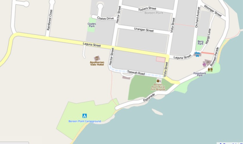
original map of Boreen Point
Over the next week this map will be updated by our team of “investigative cartographers” made up from artists and the local community as well as the visitors who come to the Floating Land Festival and Balance/UnBalance conference (which may well include you!).
Kate has done some more detailed surveying to get the ball rolling (as you’ll see in the download) and we have printed out a few hundred Field Papers to aid the DIY process. They have a set of instructions on one side and a map that you can draw on and then photograph to upload to the community on the other. While we’re ‘open for business’ up here we can handhold you through that process, but it’s also incredibly simple to do yourself. We will leave a bundle of these in the workshops tent after we have left.
Because this project is very much about open source culture, we wanted to share that experience here so that you can use the same tools and processes to enhance and update the OpenStreetMap in your area. You don’t need to be in Floating Land over the next week, or even in Queensland, to follow the same process. Download the PDF and follow the instructions, or pop along to the big red bus while we’re here (until Tuesday lunchtime). We’d love to see what you do, though, so feel free to share the link to your own maps in the comments below, or tweet @feesable and @wonderchook with your links.
Happy Mapping!